Posts filed under ‘Angel’s Rest’
Views While Nursing – Sacagawea-ing It

Sacagawea (Photo by MudflapDC)
I’ve been continuing to take an ongoing collection of views while nursing my second son. One of my favorite subset of photos are what I refer to “Sacagawea-ing It”. Sacagawea was an interpreter and guide for the Lewis and Clark Expedition. She gave birth to her first child, Jean Baptiste Charbonneau, and continued her travels with her infant son. Whenever we are out on the trails with infant Dyson, I think of Sacagawea hiking with her son.
We hiked with my older son as well, but we’ve been getting significantly more mileage in with our second. I think part of this is we know we aren’t going to break him. But another factor is the breastfeeding. You don’t have to bring along a cooler and bottles and you don’t have to time your hike between visits to the breast pump. I’ve been really enjoying how easy family hikes are and I certainly don’t mind feeding the youngest… particularly when he decide he’s hungry at a glorious overlook. 🙂
We’re still only 4.5 months into our breastfeeding journey, but here are some new “Views While Nursing…While Hiking.”
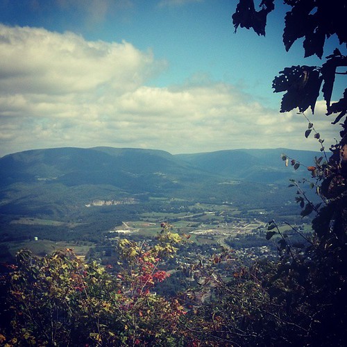
Appalachian Trails’ Angel’s Rest, Pearisburg, Virginia

Fishing Pier, Leesylvania State Park, Virginia
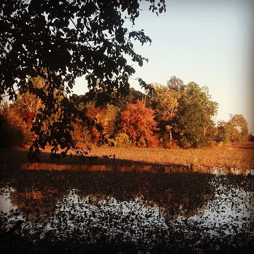
Wetlands, Veterans Park, Woodbridge, Virginia

High Point Overlook, Bull Run Mountain, Virginia

Bald Eagle Nest, Occoquan Bay National Wildlife Refuge, Woodbridge, Virginia
P.S. Instagram allows me to upload photos directly to Tumblr, so more Views While Nursing can be found at http://viewswhilenursing.tumblr.com.
Google Earth Compare: McAfee Knob and Angel’s Rest
I recently downloaded version 6 of Google Earth so I could check out some of the new 3D trees they added to locales such as San Francisco, Chicago and Tokyo. While I was flying around, I took a quick detour by one of the most photographed points of the Appalachian Trail – McAfee’s Knob (also featured in the Virginia Appalachian Trail license plate). The knob itself appears a little more green in Google Earth than in real life, but I was quite impressed by the view of Tinker Cliffs. It made me instantly nostalgic. The ridgeline was perfect!

Vicky, Jimmie and Henry at McAfee’s Knob in 2003
 Google Earth’s View of Tinker Cliffs from McAfee’s Knob
Credit: Commonwealth of Virginia via Google Earth
I also found the view of the New River, Pearisburg and Butt Mountain from Angel’s Rest to be accurate enough to make me smile and wish I was there.

Jimmie at Angel’s Rest View of Pearisburg and Butt Mountain – November 2002

Google Earth’s View of Pearisburg and Butt Mountain from McAfee’s Knob
Credit: Commonwealth of Virginia via Google Earth
I would still prefer the real thing, of course, but I have to say I thoroughly enjoyed visiting my favorite hiking spots in Google Earth!
Season Compare: Angel’s Rest
I have made many trips to Angel’s Rest over the years. Here are some comparison shots from two of those trips – October 13, 2003 and August 31, 2008.

View from Angel’s Rest – October 13, 2003

Angel’s Rest – August 31, 2008

Shot from Wilburn Valley Overlook – October 13, 2003

Shot from Wilburn Valley Overlook – August 31, 2008
Lily checks out the view at Wilburn Valley – October 13, 2003

Ryan Somma checks out the view at Wilburn Valley – August 31, 2008
The Garage, Angel’s Rest and Wanting to Cry
The week before Labor Day had its share of frustrations for me. Sunday I thought I was returning to a relatively empty house, a house that all I had left to do was touch up paint and clean. That was very far from the case. That night, weary from all the work I have already done and looking at the challenge that remained, I got a distinctive lump in my throat and my eyes started to well up. I almost cried.
Almost.
But Monday evening, it was back to work on the house. First things first. An old co-worker came by and we worked well past dark, organizing and sorting through old belongings. This effort continued the rest of the week and pretty much every item left in the house got queued in one pile or another in the garage. The project culminated Saturday and Sunday when everything got removed from the house.
It took three volunteers, a number of FreeCycle postings and pickups, three trips to the dump, two trips to the YMCA donation center, one trip to the Habitat for Humanity Restore Store, one trip to the Verizon store to recycle phones, one trip to the Blacksburg Recycling Center and one failed visit to GameStop.
Even with all that, we also managed to touch up paint two rooms, to sweep both the basement and the garage and to sweep and mop the downstairs hardwood floors. Not too shabby!
 Garage Before |
 Garage After |
It was cause for a mini-celebration. And what better way to celebrate than with my first “real” hike since Mount Rogers in June!
I chose my very favorite hike of all, Angel’s Rest. There is a lot I love about Angel’s Rest. It’s short, but steep– you ascend 1500 feet in 1.7 miles. It has great views– Angel’s Rest and then an even better one of Wilburn Valley (It is WORTH the extra mileage!). But what really differentiates Angel’s Rest from my other favorite hike contenders (Tinker Cliffs and Sinking Creek Mountain lead that list) is the sentimental value.
You see, Angel’s Rest was my very first ascent….waaaaaay back before I ever really hiked. We’re talking 1998 or 1999. Heck, I wouldn’t even own hiking boots for another four-five years! Just one weekend, I was looking for something to do with my puppy (That would be Jimmie!). I read about Angel’s Rest on the Jefferson National Forest website and decided to head westbound to the trailhead.
It took me FOREVER to get up that mountain. It seemed insurmountable!!! I thought I was going to throw up. That doesn’t say a lot though– I was emetophobic back then which means I thought I was going to throw up approximately thirty times a day. 🙂 But more telling – At one point, I turned a bend and saw the steep hill continuing. My legs were so weary from the climb I had already done and looking at the hill that remained, I got a distinctive lump in my throat and my eyes started to well up. I almost cried.
Almost.
But step by step I made my way to the rhododendron thicket near the top and then up one last steep hill to the final view.
I was elated and invigorated by what I could see. Not only was the view beautiful, but little tiny Pearisburg, little tiny Food Lion and little tiny New River carried with them the very same message as the sight of my recently cleaned garage does today:
“Job Well Done.”
Little tiny New River, little tiny Food Lion, little tiny Pearisburg
Nearly a decade later, after a frenzied week on the house, I got to hike Angel’s Rest again and I got to think about the very first time I went up that mountain. How I wanted to quit, but didn’t. And how sometimes in life, as well as hikes, you are faced with a challenge that makes you want to cry.
And how sometimes if you just take it one step at a time, your progress may seem slow, but when you look back, you can see how far you’ve come.
And somehow…when you do look back, those hills just don’t seem as steep anymore.
Of course, there were other things I thought about on the way up to Angel’s Rest. Like, pretty views and mushrooms and old towers and, of course, just how beautiful Southwest Virginia can be. 🙂

Jimmie…. still hiking with me! At Wilburn Valley Overlook.

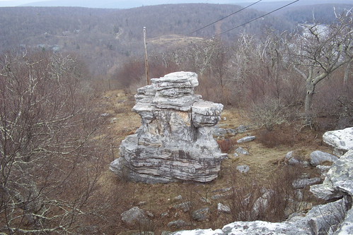
Rhododendrons through a crack in a cave

Turning leaves, spider web, power lines

Orange mushrooms

Looking up an old power line tower which nature is already taking over
More pictures of my celebratory Angel’s Rest hike can be found on my Flickr site.
Angel’s Rest & Evolution of the Appalachian Trail
For me, it is difficult to not feel a sense of history when I’m on the Appalachian Trail. The trail, which winds through mountains that are over 300 million years old, was first completed in 1937. In just in my little section in southwest Virginia, it takes you by rare virgin forests that have never been touched by loggers (the spruces found in the Mountain Lake Wilderness Area) and a tree that is over 300 years old (the great Keffer Oak). You go by old farmlands which, although unattended, still survive (the cherry orchard south of Dismal Falls). You see stunning views that we have Africa to thank for– sixty million years ago, the continent collided with Virginia and brought us the likes of McAfee Knob. You pass by reminders of our nation’s wars ranging from the Revolutionary War (Tinker Mountain is supposedly named for deserters who hid there) to WWII (the Audie Murphy Memorial on Brush Mountain). All this on a footpath that has been traveled upon for seventy-one years.

Old AT map listing the mileage as 2,007. In 2005 the total mileage had grown to 2,174.9
Interestingly enough, the AT’s abundance of history is the very trait that lulls me into viewing it as a static being, as stationary as the sandstone formations that photograph oh so well. I think of it as a constant. Yet, all around me, I can see that isn’t the case. Destroyed bridges are replaced. New shelters emerge. Or perhaps a new switchback blaze surfaces near Wind Rocks (what wise soul could have suggested that?). I see hints of the trail being rerouted– a guide book note here, a covered blaze there. And I’m well aware what was once the trail in the 1940’s is now part of the Blue Ridge Parkway (I suspect that is why that section boasts so few views– all the good parts were snatched away for the road!). Even with all that evidence, the AT in my mind, seemed so concrete.
On Saturday, I got to see first hand how fluid the trail really is. I took the dogs up to Angel’s Rest near Pearisburg. It’s my favorite hike and I’ve done numerous times in the past six years. I’ve seen that section through all four seasons and despite the changing temperatures and vegetation, the route has always been the same.
Not anymore! The Roanoke Appalachian Trail Club has finished a relocation! As a result, the early part of the ascent was all new trail to me. And… if the beautiful, brand spanking new sign at the top is correct, the AT has now grown! Perhaps I was hiking on the AT’s newest 0.2 miles. 🙂

Picture of the old AT and the new AT. To prevent confusion, RATC members piled brush on the old trail.
I did lament the loss of one or two small landmarks. And now I have no idea if my ascent time of sixty-six minutes is any better or worse than my previous personal best of sixty minutes. But all in all, it was a thrill to see the AT change before my eyes. Afterall, it’s the trail’s ability to change, to reroute and evolve, that has allowed it to accumulate the deceptive history it has. 🙂
One very important item remained the same on Saturday and I expect it to remain the same for years to come– the views on Pearis Mountain are spectacular:

View of Wilburn Valley (on AT south of Angel’s Rest)

View of Pearisburg, Virginia from Angel’s Rest

Remaining Leaves and Wilburn Valley
More pictures of my Angel’s Rest Hike can be found on Flickr.
ISO: Fireworks From a Hike
I realized this week that I’m going to be in town on the 4th of July! I’m on a mission– This year I would like to camp and watch fireworks from an overlook. Last night I came up with some possible contenders.
Please note these are all speculations at the moment. I can not confirm fireworks can be seen from these spots:
Kelly’s Knob (Appalachian Trail)
From Kelly’s Knob you can see Blacksburg and Virginia Tech…. so it makes sense you would be able to see fireworks above Blacksburg. The area has plenty of room for camping and some existing fire rings.
McAfee’s Knob (Appalachian Trail)
From McAfee’s Knob you can see Roanoke Airport as well as plenty of valleys. With its 270 degree view and its vicinity to Roanoke, it seems like a good candidate to see fireworks somewhere.
Angel’s Rest (Appalachian Trail)
This one I think is iffy. You can see quaint Pearisburg and Narrows from the overlook– but a portion of Pearisburg is not in sight. I couldn’t find any information on Pearisburg’s celebration plans. Not knowing where the fireworks are being launched from (I highly doubt it is from the supermarket directly ahead of the knob), it’s a bit of a risk.
This morning I consulted my original hiking buddy and New River Valley sherpa, Tony Airaghi. Turns out he was already working on similiar plans. He brought a new candidate to the table, which is our tentative winner:
Butt Mountain Overlook
Butt Mountain is not off of the Appalachian Trail, but it does provide expansive views of Pearisburg, Narrows, Pembroke and Newport. Tony believes we may even be able to see Blacksburg fireworks from that spot as well. If all goes right, we’ll be able to watch multiple communities celebrate in one sitting. And the thing that really gave Butt Mountain the edge– you can drive pretty darn close to the overlook with 4WD. This is a plus as Tony sprained his ankle this past week.
Welp, I’ll be sure to report back next week. In the meantime, if you have any other candidates or any details on these locales– let me know!
July 4, 2007 Edit:
The Roanoke Times introduced another contender in their July Fourth celebrations article– Sharp Top to watch the Peaks of Otter display:
Fourth of July at Peaks of Otter
National Park Service rangers lead the annual walk up to Sharp Top to view the fireworks. Bring sturdy shoes and a flashlight for the 6-mile round-trip hike. 7 p.m. Wednesday. Nature Center, Peaks of Otter. 586-4496.
Pearis Mountain in the Snow
For those of you who don’t know, I have a new boss! And apparently he knows me well. When he was telling me I could pick my own work hours, the example he used was, “So you can hike in the morning and work in the afternoons and evenings.” 🙂
Sounded nice, but I didn’t expect to take advantage of it so quickly. Well Tuesday night we finally got a snow down here in Blacksburg. Like my friend, Mandy said recently on her blog, “this may be THE snow of 2007!” So I called my new boss and he gave me permission to go (even though it meant missing a conference call).
This is what we do for love! The next morning, I woke up earlier than I do for work. I got dressed up in my layers, grabbed Jimmie and headed out in the X-Terra on snowy roads.

Morris Street in Pearisburg (I was not driving the vehicle during this shot).
Henry the beagle sat this one out. Although Henry is three years younger than Jimmie, he’s already threatening to retire from hiking. He has some back problems and he looked stiff after the Brush Mountain hike. Henry was assigned a very important duty though. He had to lay in bed, watch TV and keep Sean company.
Our destination was my favorite mountain — Pearis Mountain which is home to Angel’s Rest. In recent years, my longer outings with Mike E have made Tinker Mountain a worthy rival for the favorite mountain title. The two mountains are pretty neck and neck, but Pearis has been the incumbant for years, so I’ll give it the edge.
It was a beautiful, invigorating hike. Jimmie and I were the first to walk on that snow, so all you have was the trail and our footprints.

Bend in the Appalachian Trail on Pearis Mountain
Despite the snow I was making good time…for me (I’m notoriously slow at ascents). I could get snippets of the view to come between the trees and I knew it was going to be great. And I found myself counting chickens before they hatch. I was already planning on who I was going to send picture messages to from the top. Derek, Sean, Ann, Mike’s email (how do I have a friend without text messaging? Even my mother has it!), Larry, etc. A while after I passed the old power line tower, I hit a snag.
I slipped and fell. That’s not unusual– I have fallen before on hikes. In fact one time on the way to Dismal Falls I managed to fall flat on my face within ten feet of getting on the trail! So I got up and continued on. Before I knew it I slipped and fell again.
What in the world was going on? I wiped away the snow and discovered that underneath was a continuous sheet of thick ice. It was nothing like the ice I saw on Brush Mountain.

What’s underneath that snow? Why a thick sheet of ice, that’s what!
I did give the trail a very cautious benefit of the doubt. I had to be cautious– we can’t have me and Sean with broken feet, can we? I continued on for another switchback or two (sometimes using the nearby trees as security), but the conditions did not improve. Jimmie, of course, had no problem whatsoever. I tried to follow his lead and “Four Wheel” it for a while, but that didn’t work. Jimmie’s dainty little feet didn’t sink all the way through the snow, so he always had some traction. I was heavy enough that I always contacted the ice. Blast that Britney Spears weight.
As usual, Jimmie was ahead of me. Everytime I slipped, he’d look back and appear so baffled. I had to laugh– I kept thinking about the game of touch football in the movie Wedding Crashers.

“What are you doing? […] every time I look over you’re on your ass again!”
Jimmie and I were oh so very close to the top. We had passed that last rocky crossing and were already seeing the rhododendrons that cover the top. Very tempting, but we summoned the strength to wuss out and headed home. Although I knew the view would be “to die for”, I also knew it wasn’t actually worth dying for.

As far as we got– view near the top of Pearis Moutain
It was still a wonderful outing and great exercise. Just a splendid morning and suddenly even late afternoon conference calls went by quickly. 🙂
All my pictures from this snowy Pearis Mountain hike are available on my Flickr site.
P.S. That night, my new boss treated me to a hot chocolate. Am I living the life or what?
Something the Thru-Hikers Miss
Each year over a thousand hikers embark on hiking the whole Appalachian Trail. I think there is roughly a 20-25% completion rate. These hikers, even the ones who don’t manage to finish, gather up memories of the trail that I, as a mere day-hiker, can only imagine. I certainly enjoy my showers and hot meals, but I do envy the unique experiences those hikers must have. Parting with all the daily obligations of their lives, all the views they see as they travel through fourteen states, the comradery they have with other hikers and finally, the fulfillment they must feel 2000 miles later when they have completed their challenge.
Yesterday, Bill and I made a trip down to the Butt Mountain Overlook. It was a quick trip– We headed that way, admired the view, took some pictures, watch Jimmie take three dumps and two hours later we were back home. Last night when I was looking at one of my pictures of the view, I recalled I had a similiar shot from a July trip with Mike E. It was neat to flip back and forth and look at the difference.
Then I was reminded… The thru-hikers who pass through this area each year certainly have a wealth of experiences that I do not have, but there is one thing I have one thing that they don’t. I get to see this area year-round. I get to see the same spots through different seasons and different weather conditions. I get to see the blooming rhododendrons in June and I get to see them all curled up in the winter, adding a green contrast to the white snow. I know that Angel’s Rest is best in the fall, the Cascades are the prettiest in the winter* and Wind Rocks is so very haunting in the fog. In the early spring and winter I get to see extra views before the leaves are on the trees that you would never notice in the warmer months (for example you can see only Mountain Lake from Bald Knob when there are no leaves) when the thru hikers are passing through. And then when the leaves are there in the summer, I get to marvel at the beauty of all the green along with all the other hikers.
I’d say the score is still about 1279 to 2 (I’m also counting “Sitting in Larry’s Hot Tub Afterwards” as a point for me). But for what it is worth, here are some samples from my hiking photos of similiar shots in different seasons (Note: Not all are Appalachian Trail hikes). Enjoy!
Butt Mountain

Winter

Summer
Bald Knob
Spring – You can see Mountain Lake in the upper right

Summer – No Lake Visible
Falls Ridge

Winter

Late Fall
McAfee’s Knob

Spring

Summer
Cascades

Strong Winter

Mild Winter

Spring
Carvin’s Cove

Spring

Summer
Pearis Mountain (Past Angel’s Rest)

Spring (this was my 30th birthday hike!)

Summer
*The Thru-Hikers would certainly struggle to know Cascades is prettiest in winter seeing as how it isn’t on the AT.
“People Get Held Back By The Voices Inside Them”
With a few recent exceptions, every hike I go on, at some point I think I can’t make it. That doubt typically surfaces during an ascent. 🙂 For example, last year’s Tinker Cliffs to McAffee’s Knob Hike– I made it up to Tinker’s Cliff fine, but at the halfway point when we started a slight rise right after Brickey’s Gap, a subtle lump rose in my throat, I thought about the path ahead and I wanted to cry.

But as with all hikes, I keep going and before I know it, I’m at the top or in sight of my car and I’m ready for a nice Fuddrucker’s hamburger or better yet, some ice cream.
It is my mind that doubts what my body can do!
This knowledge has come in handy in my professional life. Last July, I had a very hectic travel schedule. In looking over the back to back itineraries and flights, I thought to myself, “I can’t do this! It’s impossible!” Then I remembered all the hikes where a similiar thought crossed my mind. I took it one trip at a time and like hiking, I drank a lot of water and ate well. Before I knew it, I was through all my obligations and I had a great deal of fun while I was at it.
Unfortunately, now I’m on to myself. On five recent hikes (Tinker Cliffs to VA-220, VA-635 to Pine Swamp Shelter, Blackhorse Gap to VA 652, Mount Rogers and Bald Knob), I knew better. I never thought I couldn’t make it. But, with Mt. Bierstadt I definitely had my doubts! Those doubts were a slightly different species, however– they occurred before I even arrived in the state.
When Mike Newman first emailed me the trail info, the elevation gain of 2,850 feet stuck out to me.

Although I had ascended 3000 feet on a hike on an Appalachian Trail, that was spread out over the course of 13 miles. With Mount Bierstadt, the elevation gain was pretty much compacted to a 2 mile area.
Anyone who has hiked with me, knows that I am quite slow on the steep inclines and take a lot of breaks. Add the thin air to the mix, it seemed to be an impossibility.
“It’s like two Angel’s Rests back to back,” I lamented to friends, “with 1/3 the oxygen!”
Enter Mike Newman who was not deterred one bit by my concerns.
“I honestly think you can do it, and you won’t exhaust my patience–you’ll just have to trust me on that one,” he emailed.
It turns out, Mike Newman was correct on both accounts. As soon as I was on the trail, I was no longer concerned. And although I was challenged by the rocky, steep sections– there was never a time where I wanted to turn back…and certainly never a time where I wanted to cry. By the time the trail got hard, the summit was close enough that I knew it was obtainable (though I still reveled in my surprise that I was going to make it). The whole while, break after break, Mike Newman proved to be a very patient and pleasant companion (He also demonstrated an uncanny ability of estimating the number of paces to the next cairn). It turned out to be a wonderful, fulfilling day.
If I had listened to my own doubts or let my worry of irritating Mike Newman win out, I would have settled on a very different hike. I would have missed out. And ultimately what was I worried about? I was worried about looking like a wuss. I would have missed out because I was trying to save face!
This all reminds me of another K’naan quote from The Beginning
People get held back by the voices inside them
I’m glad, thanks to Mike Newman’s encouragement, that I did not fall into that tempting pitfall.
I’m glad that I did not get held back by the voices inside me.


Recent Comments