Posts filed under ‘trees’
Walking Tree Wanna-Be
A few weeks ago, Brian Vandervort sent me this picture he took in Costa Rica. It’s of a “Walking Tree”. By adding and subtracting roots, this tree actually moves itself to better sunlight and soil!
Walking Tree in Costa Rica
Last week at Apple Orchard Falls, I saw a tree that looked like it aspired to its Costa Rica relatives.

Walking Tree of Southwest Virginia?
I’m not sure what caused this unique root structure (other trees had their roots firmly underground, so I don’t think it is an erosion issue), but this tree sure looks like it wants to go somewhere.
Additional Links
Thinking Like a Tree article from MIT
Google Answers Thread on Walking Palms
Quick Correction to “Quick Trip, Quick Post”
In Quick Trip, Quick Post, I discussed the blooming order of three common trail plants. I said it went Azaleas -> Mountain Laurel -> Rhododendrons.
Welp, on our hike this week, I saw some solid examples that I was incorrect. Here’s a shot close to Apple Orchard Falls. It depicts rhododendrons in full bloom. Meanwhile the mountain laurel is just getting its start, its flowers hadn’t even opened!

Whoopsie. Rhodos in full bloom. Mountain Laurel just starting.
But on the upside, I can report that rhododendrons are still my favorite of all evergreens. So the Christmas Tree can continue to suck it. 🙂
Petites Gap to Cornelius Creek Shelter – Wildflower Row
On Saturday, I joined a group of six other hikers (mostly from the Charlottesville/Potomac Appalachian Trail Club area) for a hike along the Appalachian Trail. We started at Petites Gap which is Mile Post 71 on the Blue Ridge Parkway. We hiked about 7.3 miles on the AT, then we went 1 mile down Apple Orchard Falls Trail to Apple Orchard Falls. From there, we backtracked 0.5 miles up Apple Orchard Falls Trail. Next we cut across Apple Orchard Road 1 mile to Cornelius Creek Trail. We ascended 0.6 miles to get back to the AT. Finally, we hiked 1.6 miles down the AT to the Cornelius Creek Shelter. We ended back up at the Blue Ridge Parkway at Mile Post 80.5.
This section of trail had it all– views, waterfalls, wildflowers. It offered so much, it felt like 4-5 different hikes combined into one. Some many features of this section are described below:
View of Devil’s Marbleyard
As we ascended through Thunder Ridge Wilderness, we pass a rock outcropping with a views of Devil’s Marbleyard. It’s quite a different perspective than Mike E and I had a few weeks ago at the Marbleyard.

Devil’s Marbleyard from Thunder Ridge Wilderness
Thunder Ridge Overlook
Also accessible from the Blue Ridge Parkway, we passed by an overlook near the high point of Thunder Ridge.

View from Thunder Ridge Overlook
The Guillotine
As we neared the summit of Apple Orchard Mountain, we passed under a boulder balancing precariously above the trail.

Ken, with remarkable faith, sits on top of the Guillotine with the Appalachian Trail below
Apple Orchard Summit
Our passage took us to the summit of Apple Orchard Mountain. At 4225 feet, this is the highest point the trail reaches in some time. Northbound hikers would have go to 1000 miles to New Hampshire to reach a higher elevation. Meanwhile Southbound hikers would need to go 600 miles.

Summit sign at Apple Orchard Mountain

View from summit of Apple Orchard Mountain
Apple Orchard Mountain was named for the trees at the top. They are not apple trees, rather they are red oaks that have been twisted and deformed by wind and ice. To the locals, the trees appeared to be a deserted orchard. Thus the name.

Namesake of Apple Orchard Mountain
The summit sports more than trees and great views. An FAA air traffic radar tower is present up there as well.

FAA Radar Tower at top of Apple Orchard Mountain
Apple Orchard Falls
Our side trek took us to beautiful 150-foot Apple Orchard Falls.

Apple Orchard Falls
Black Rock Overlook
One of our final stops of the journey was Black Rock Overlook which provides outstanding views, including Peaks of Otter to the left.

Layers of ridges visible from Black Rock

Peaks of Otter (Flat Top) from Black Rock
Wildflowers
Last, but not least, our hike provided us with a steady stream of wildflower viewing opportunities. The Appalachian Trail Guide to Central Virginia describes this section well.
This area is famous for its spring flowers– acres of large flowered trillium, being crowded by mayapple, as well as a showing of bloodroot, showy orchids, large-flowered bellwort, mountain lily-of-the-valley, blue cohosh, and rattlesnake plantain (an orchid).
However, we met a thru hiker named Biker Barb who improved upon the guidebook’s description.
It is like walking through a botanical garden.
Biker Barb was right. Our journey provided such a variety and high quality of specimens, it very well could have been a botanical garden.

To Be Identified — Chickweed?

Mayapple which has a single stealth bloom underneath a broad leaf canopy

Jack in the Pulpit

Two of the thousands of trilliums on the trail

Pink Lady Slipper Orchids

To Be Identified – Spiderwort?

Rhododendrons

Mountain Laurel
It was a wonderful and fulfilling journey. Many thanks to Jere Bidwell for organizing this trip and inviting me!!!
Additional Links
Many, many more pictures on Flickr
Kevin Myatt’s article on Apple Orchard Falls for the Roanoke Times
Thunder Ridge Wilderness Area
Quick Trip, Quick Post
I worked in Roanoke again today, but still managed to get outside before dark. The dogs and I did just the ascent from VA-601 towards Kelly’s Knob. I am horribly slow on the uphills, so I targetted this section because it had the best ratio of steepness to driving distance. My intent was pure practice, but I ended up taking lots of pictures on the way back down. Some shots:

Jimmie off the AT

Some ferns off the AT

A Fence Post off of VA-601
Blooming Season – Azaleas, Mountain Laurel and Rhodos
If I recall correctly, azaleas usually bloom first, then mountain laurel and then finally my favorite of all evergreens (suck it, Christmas Tree!)– the wild* rhododendron. I saw some azaleas already blooming (pink and orange varieties) and the mountain laurel was getting poised. Before we know it, Southwest Virginia is going to be in its prime rhodo season. Rhodos are pretty prevalent on the trail around here, but I would rank Angel’s Rest (Pearisburg, VA), Dragon’s Tooth (Catawba, VA) and, of course, famous Rhododendron Gap (Marion, VA) as some of the better spots.

Pink Azaleas Blooming

Mountain Laurel at Sunset
All my pictures from our John’s Creek Mountain Outing can be found on my Flickr site.
*I have a distinct distain for cultivated rhododendrons. I’ll have to save that for another post on another day.
Hungry Trees
At Caldwell Fields, I found more trees absorbing an obstacle. This time they were eating wires.
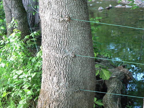
Three wires almost look like they were threaded through the tree.

Close shot of an absorbed wire
As a refresher, the other hungry trees were at Bottom Creek Gorge and on the John’s Creek Mountain Trail:

Hungry tree at Bottom Creek Gorge

Hungry tree on John’s Creek Mountain Trail
Now that I think about it, Granary Cemetary in Boston had a hungry tree too:

Trees in Boston have a taste for tombstones
Yeah…remind me to never get in the way of a tree.
Trees That Could
I’m continually amazed by perseverance of trees. I’ve seen plenty that manage to thrive despite less than optimal conditions. Tony and I ran across another resilient example today on the Huckleberry Trail. This particular tree is growing on the rocky hillside near Mile Marker 5. Check out the root. It snakes around rocks and down, down, down until it finally reaches nutrients.

A very dedicated root system

A closer shot showing the path the root took
In posts on Bottom Creek Gorge and John’s Creek Mountain Trail, I highlighted some trees that were not intimidated by obstacles. They simply grew into and absorbed the obstruction. On Sunday, the dogs and I hiked the Royale Trail at Poverty Creek and we ran across a tree that took a less invasive approach:

This tree grew in a perfect half circle. Hikers and bikers have lined stones up to and on the tree.


Recent Comments